|
Benutzerhandbuch — iPhone & Apple Watch
|
||
|
|
|
MetrO ist Ihr kostenloser Smartphone-Führer für den öffentlichen Nahverkehr weltweit. Die App deckt mehr als 400 Städte ab — U-Bahn, Straßenbahn, S-Bahn, Bus, VAL, Standseilbahn — und berechnet Ihre Routen vollständig offline, ohne Internetverbindung, direkt auf Ihrem iPhone.
Im App Store erhältlich. MetrO wird seit 1997 von Patrice Bernard & Frank Van Caenegem (Kinevia) entwickelt.
MetrO ist kostenlos. Helfen Sie uns im Gegenzug, Änderungen in Ihrem Verkehrsnetz über die Funktion Kommentare senden zu melden.
Diese Anleitung beschreibt die Funktionen der iPhone-Version und der Apple Watch Begleit-App.
Benutzeroberfläche — Der Hauptbildschirm umfasst:
- Zwei Eingabefelder:
 Abfahrt und
  Ankunft
 - Eine Symbolleiste zur Anpassung der Berechnung:
 Berechnen ·
 Umkehren ·
 Löschen ·
 Mein Standort ·
Fahrplan
Mein Standort ·
Fahrplan - Eine Tab-Leiste unten:
 Haltestellen ·
 Linien ·
 POI ·
POI ·
 Teilen ·
 Einstellungen
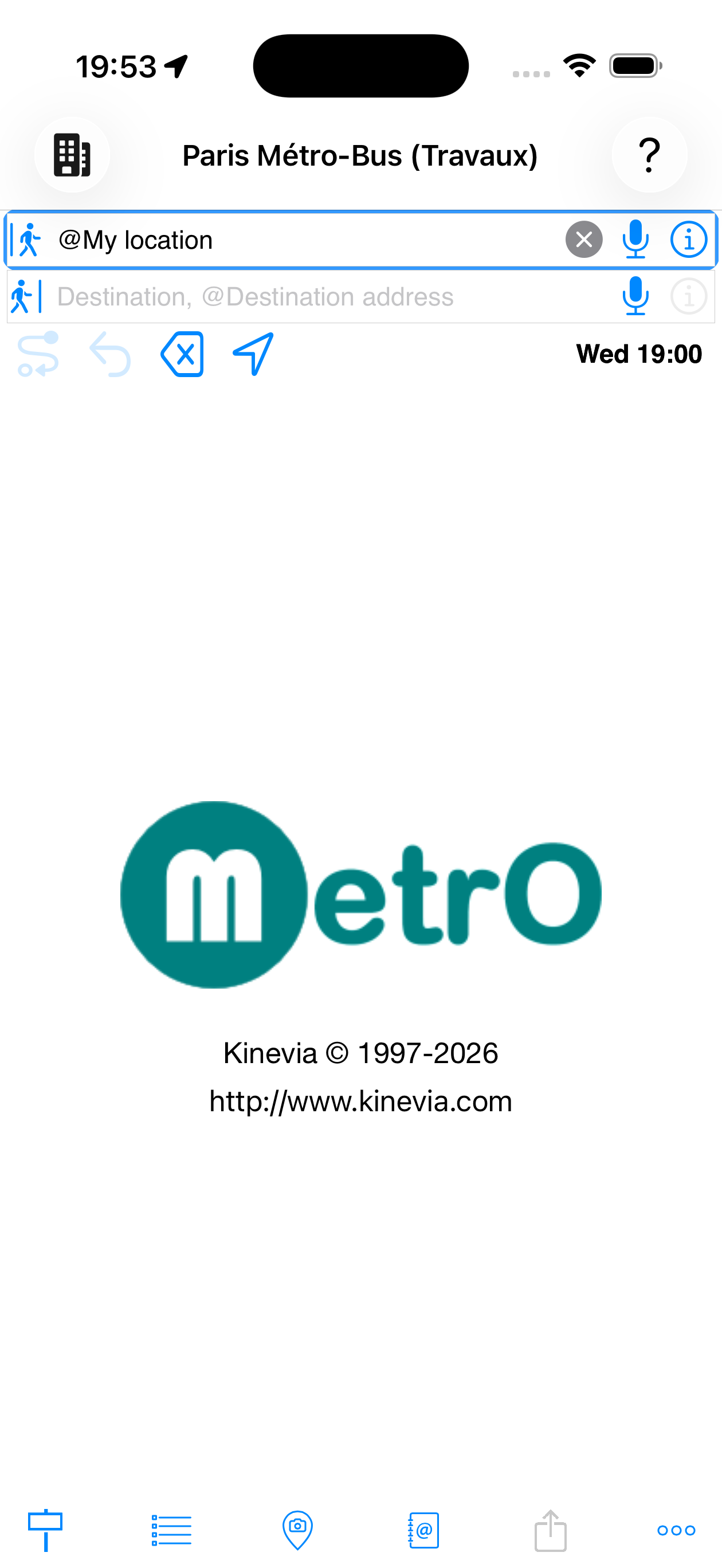
Bevor Sie eine Route planen, wählen Sie die Stadt aus, in der Sie reisen möchten. Tippen Sie auf das
![]() Symbol oben links, um die Liste der verfügbaren Städte zu öffnen.
Symbol oben links, um die Liste der verfügbaren Städte zu öffnen.
- Installierte Städte zeigen ein
 Papierkorb-Symbol
 - Städte in der Nähe Ihres Geräts (ca. 50 km) erscheinen in Blau
- Zum Download verfügbare Städte zeigen ein

- Eine alphabetische Suchleiste auf der rechten Seite ermöglicht schnellen Zugriff
- Tippen Sie auf „Städte laden", um neue Daten herunterzuladen (Verbindung erforderlich)
Sobald eine Stadt ausgewählt ist, gelten alle Suchen ausschließlich für deren Verkehrsnetz.
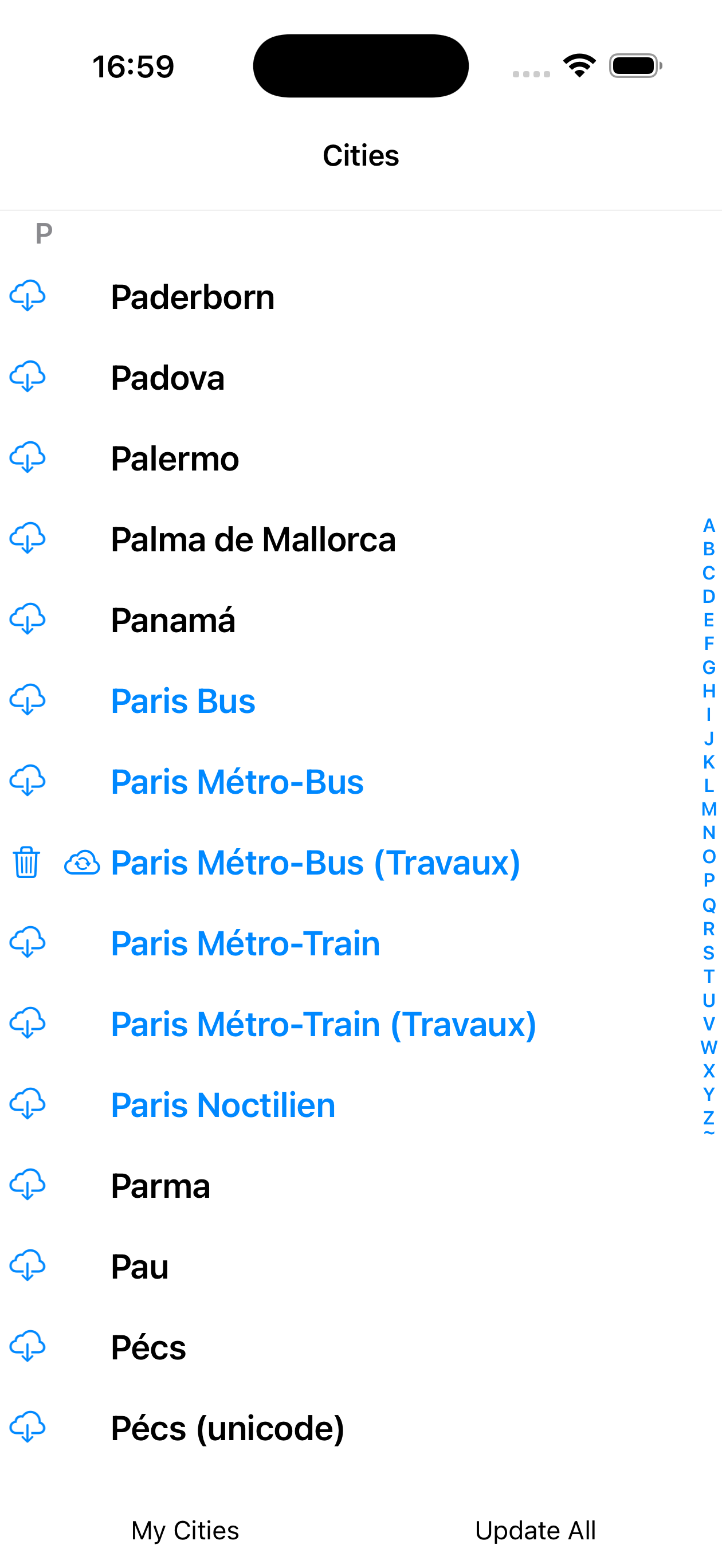
Städte
Farbkodierung der Städte
| Anzeige | Bedeutung |
|---|---|
| Name in Blau | Stadt, deren GPS-Standort in der Nähe Ihres aktuellen Standorts liegt — MetrO schlägt sie zuerst vor |
| Name in Grau | Daten sind veraltet — Aktualisierung empfohlen |
| Stadt lokal installiert — kann gelöscht werden, um Speicher freizugeben | |
| Update verfügbar für eine bereits installierte Stadt | |
| Stadt zum Herunterladen verfügbar (noch nicht installiert) |
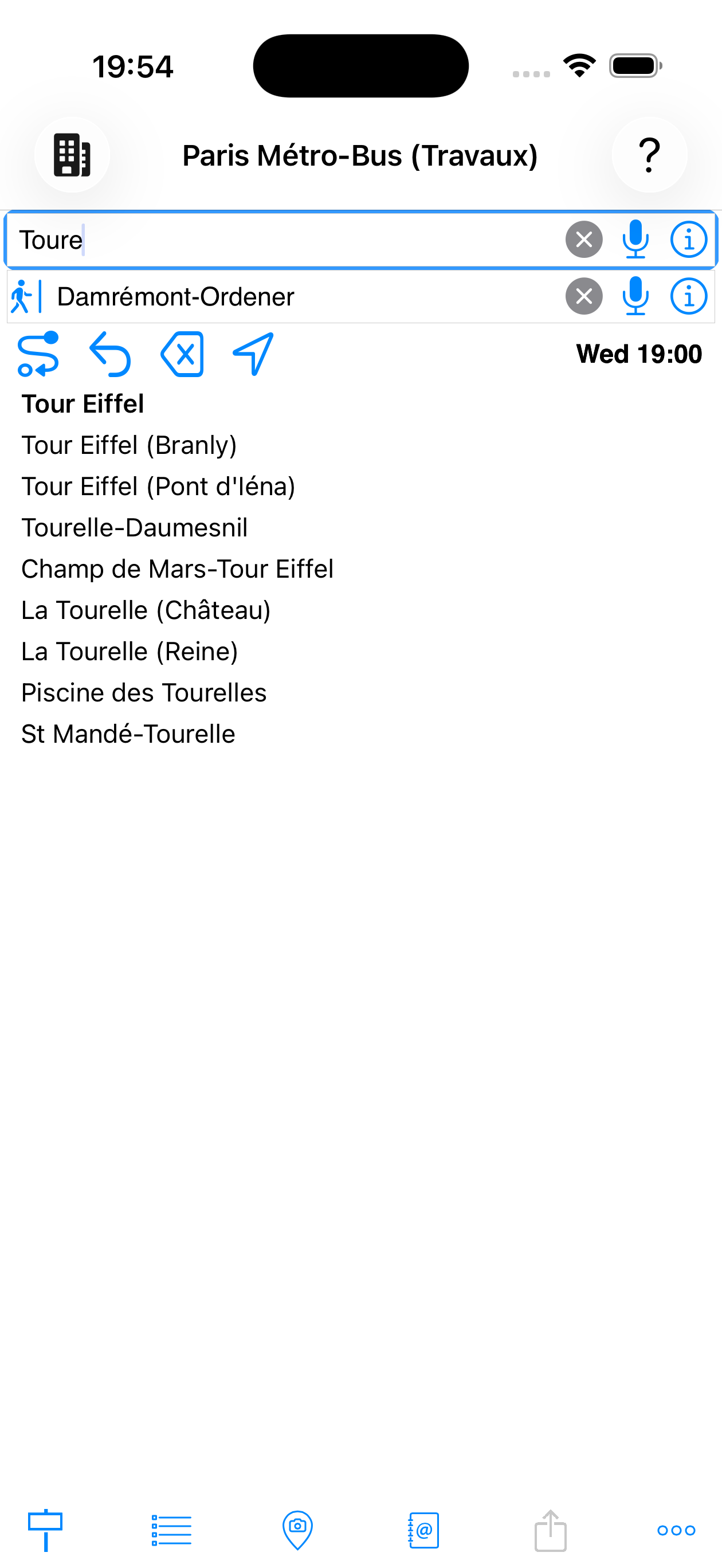
1. Abfahrt und Ankunft eingeben
Tippen Sie auf das ![]() Abfahrtsfeld und geben Sie die ersten Buchstaben ein. MetrO zeigt sofort passende Vorschläge. Gleiches gilt für das
Abfahrtsfeld und geben Sie die ersten Buchstaben ein. MetrO zeigt sofort passende Vorschläge. Gleiches gilt für das ![]() Ankunftsfeld.
Ankunftsfeld.
- Die Suche umfasst Haltestellennamen, Adressen und Sehenswürdigkeiten
- Das
 Mikrofon ermöglicht Spracheingabe
 - Die Taste tauscht Abfahrt und Ankunft und berechnet die Route in umgekehrter Richtung
- Die Taste
 leert das aktive Feld
 - Die Taste
 öffnet das Detailblatt der ausgewählten Haltestelle
Tippen Sie auf ![]() um die Berechnung zu starten.
um die Berechnung zu starten.
beim Tippen
Die Symbolleiste unterhalb der Eingabefelder enthält die Berechnungsschaltflächen von links nach rechts:
| Schaltfläche | Funktion |
|---|---|
| Route berechnen — startet die Berechnung mit den aktuellen |
|
| Route umkehren — tauscht Abfahrt und Ankunft und berechnet die Route in umgekehrter Richtung | |
| Löschen — setzt beide Felder zurück | |
| Mein Standort — verwendet GPS, um das aktive Feld mit Ihrer aktuellen Position zu füllen | |
| Mo. 10:00 | Abfahrtszeit — tippen Sie, um den gewünschten Tag und die Uhrzeit auszuwählen. MetrO berücksichtigt echte Fahrpläne (Nachtverkehr, Sonntage usw.) |
| ☀ 23°C | Wetter am Ziel — erscheint automatisch nach dem Laden der Daten. Zeigt die Temperatur am Ziel. Tippen, um das stündliche Vorhersage-Panel zu öffnen (siehe Abschnitt Wetter & AQI) |
| Stadtinfo — Zeigt detaillierte Informationen zur aktiven Stadt: Statistiken, Update-Hinweise, Tarife, Warnungen bei Bauarbeiten |
Stadtinfo-Seite
Die Stadtinfo-Seite zeigt:
- Stadtname und letztes Aktualisierungsdatum
- Statistiken: Anzahl der Linien, Haltestellen, Favoriten
- Versionshinweise, Tarifbedingungen und Baustellen-Warnungen
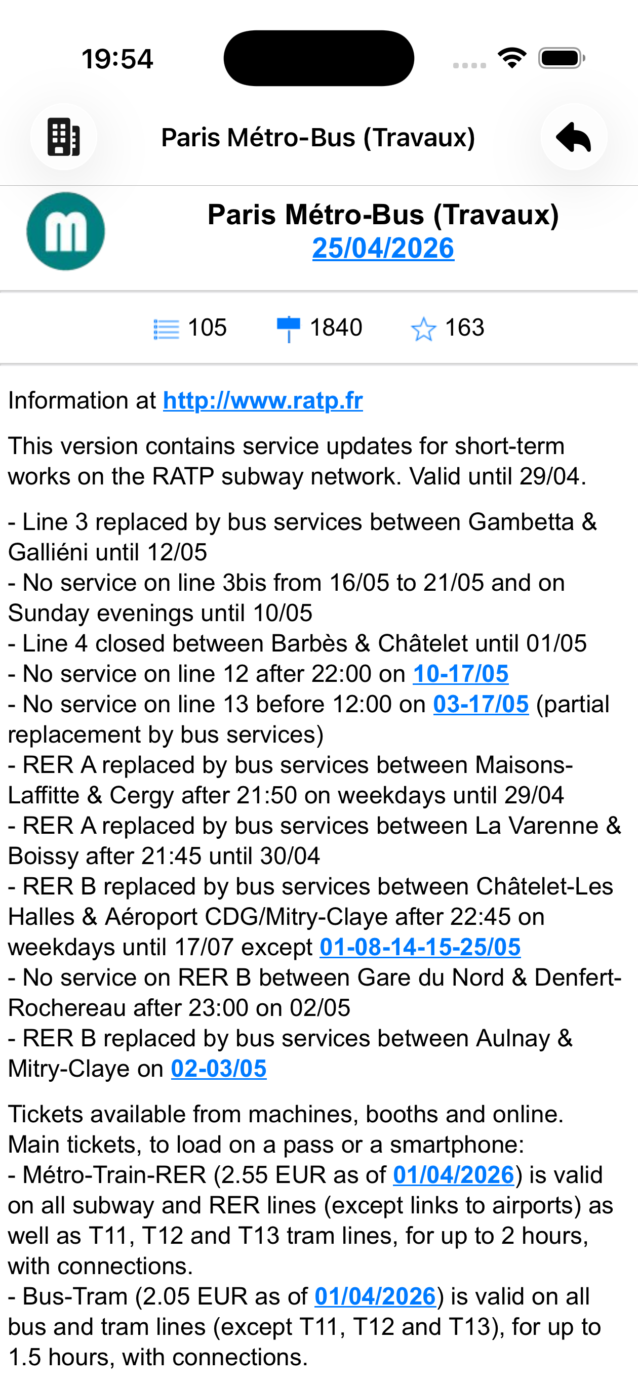
Paris Métro-Bus
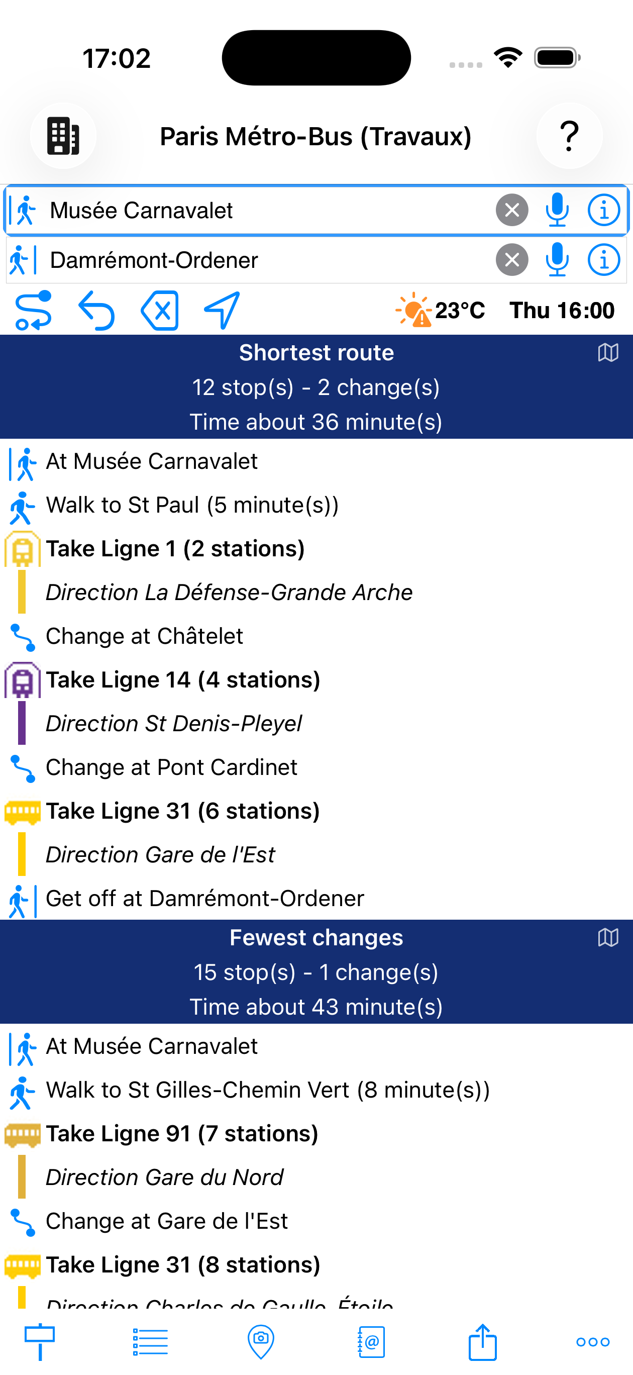
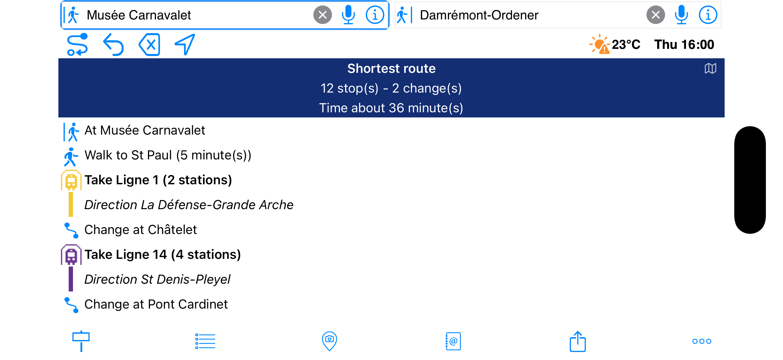
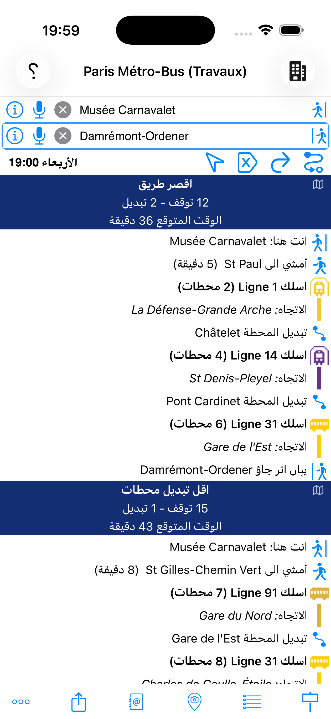
2. Ergebnisse lesen
MetrO berechnet und zeigt mehrere Routen gleichzeitig:
- Dunkelblauer Banner — Zusammenfassung: Anzahl der Haltestellen, Umstiege und geschätzte Dauer
- Fußweg-Schritte
- Zu nehmende Linie mit farbigem Symbol, Richtung und Haltestellenanzahl
- Umstieg
- Aussteigen bei
berechnet
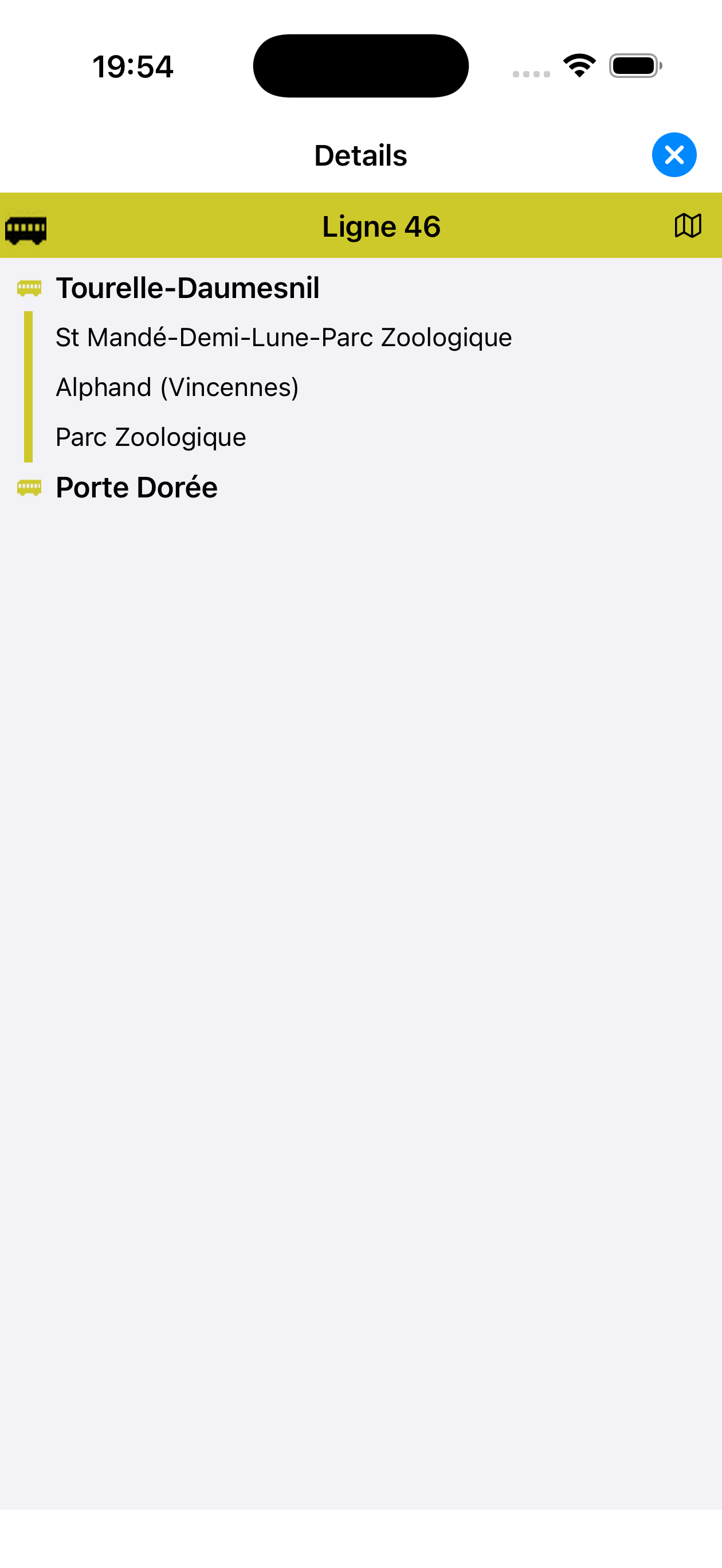
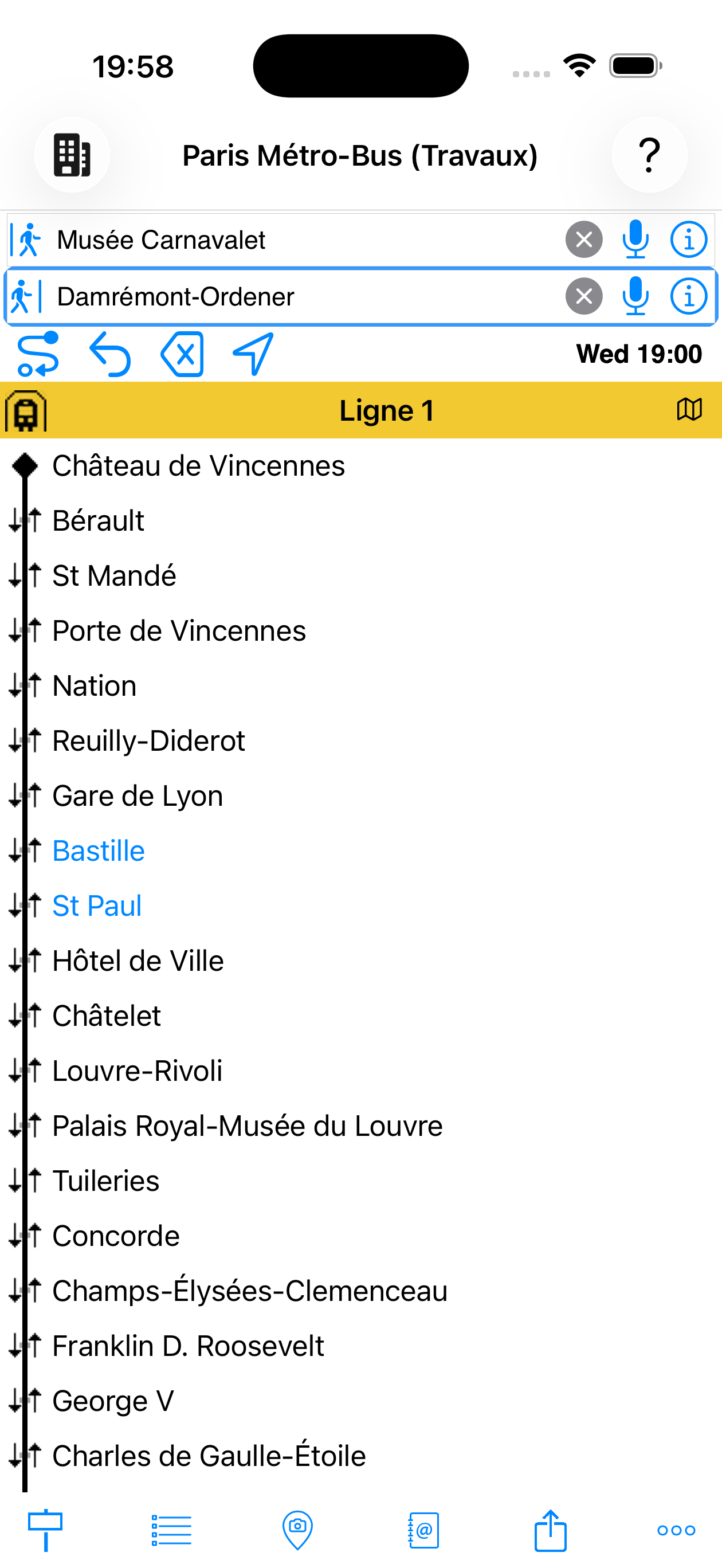
3. Haltestellen einer Linie anzeigen
Tippen Sie auf eine Linie in den Ergebnissen, um die vollständige Liste ihrer Haltestellen in der gewählten Richtung anzuzeigen.
aus den Ergebnissen
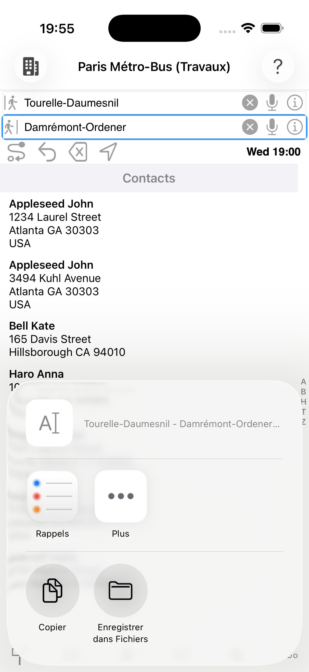
Neben Haltestellennamen akzeptiert MetrO verschiedene Eingabetypen für die ![]() Abfahrts- und
Abfahrts- und ![]() Ankunftsfelder:
Ankunftsfelder:
Zuletzt genutzte Einträge werden bei Aktivierung des Felds vorgeschlagen
Museen, Bahnhöfe, Flughäfen, Einkaufszentren…
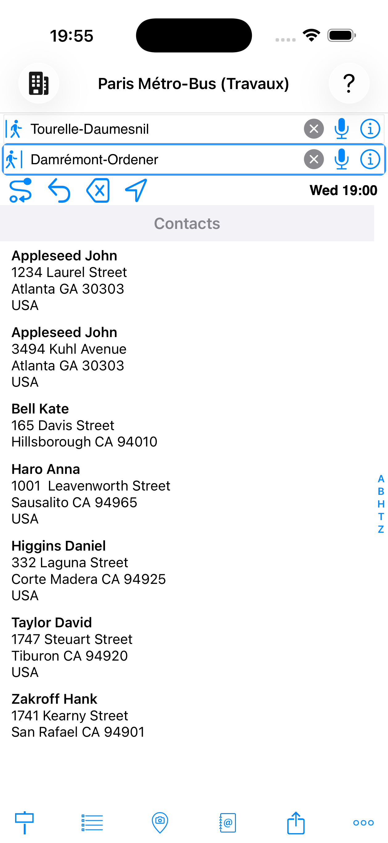
Adressen aus Ihren iOS-Kontakten
Weitere Eingabemethoden:
- Mein Standort — „@Mein Standort" verwendet Ihre GPS-Position als Abfahrtspunkt
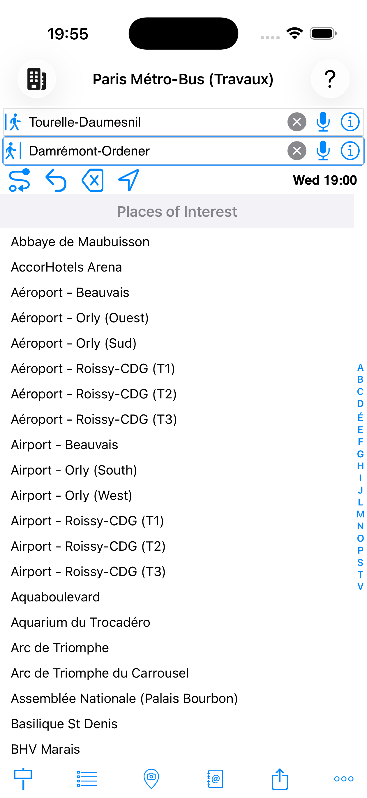
- Haltestellen-Tab — zeigt abwechselnd die vollständige alphabetische Liste aller Haltestellen der Stadt oder den Verlauf der letzten Suchen
- POI-Tab — Sehenswürdigkeiten
MetrO sucht automatisch die nächstgelegene Haltestelle zum ausgewählten Ort.
Zuhause und Arbeit
Wenn Ihre persönliche Kontaktkarte (Ihr eigener Eintrag in iOS-Kontakte) eine Privat- oder Arbeitsadresse enthält, schlägt MetrO diese automatisch als Zuhause und Arbeit in den Eingabevorschlägen vor — ohne zusätzliche Einrichtung.
Sie können diese Aliase auch direkt in ein Eingabefeld eingeben:
- Zuhause — akzeptierte Aliase:
@Zuhause·@Wohnsitz - Arbeit — akzeptierte Aliase:
@Arbeit·@Büro
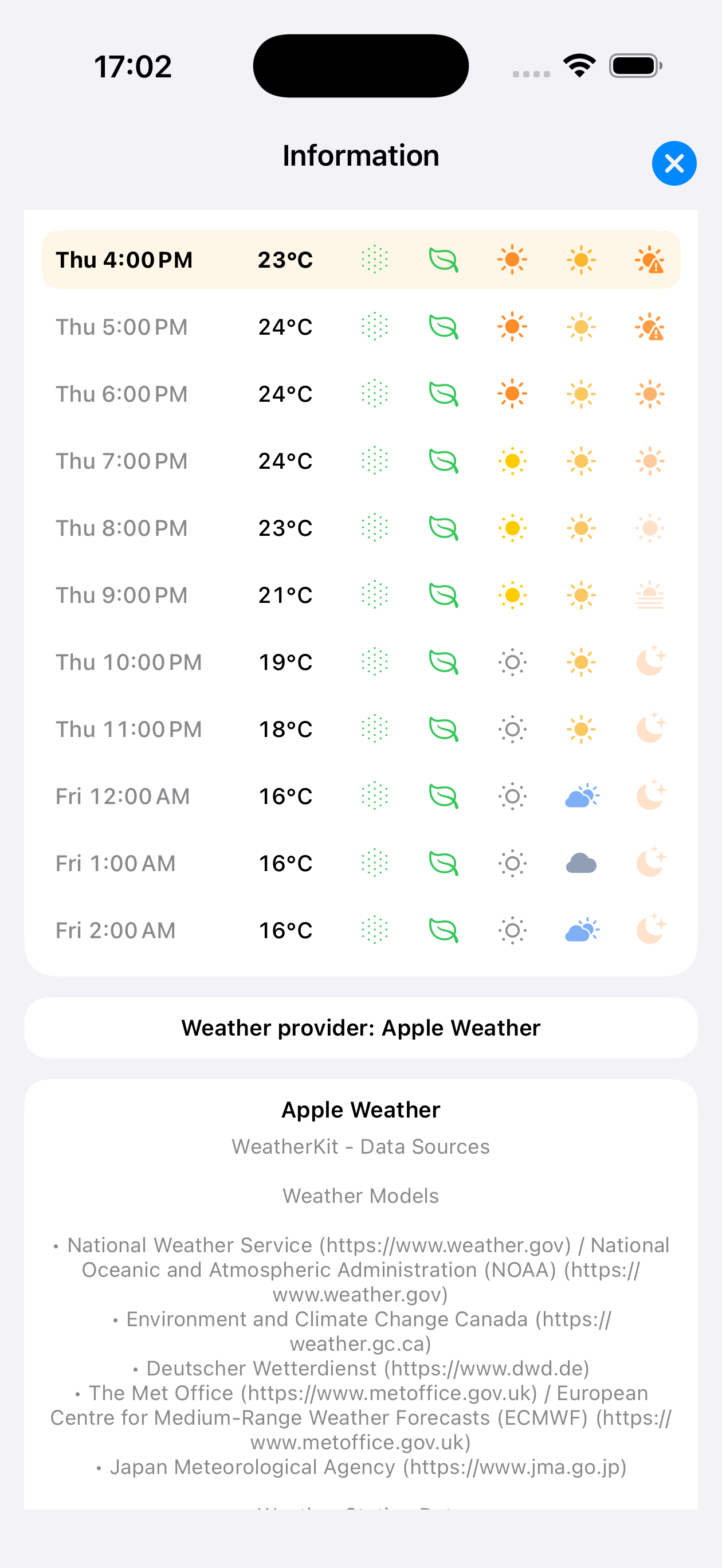
Wenn MetrO die GPS-Koordinaten des Ziels und eine Internetverbindung hat, erscheint automatisch eine Wetter-Schaltfläche neben der Fahrplan-Schaltfläche in der Symbolleiste. Sie zeigt die aktuelle Temperatur am Ziel mit einem Zustandssymbol (Sonne, Wolken, Regen…).
Ein Tippen öffnet ein stündliches Vorhersage-Panel für die kommenden Tage. Jede Stunde zeigt:
- 🌡 Temperatur — in Grad Celsius
- ☀ Sonnenschein — Intensität der Sonnenstrahlung
- 🍃 AQI (Luftqualitätsindex, US-Skala) — Luftqualität: 0–50 gut, 51–100 mäßig, 101–150 ungesund für empfindliche Gruppen, >150 ungesund
- 🌿 Pollen — Pollenbelastung (Gräser)
- ☀ UV — Ultraviolettindex
- Wetter-Zustandssymbol — klar, bewölkt, Regen, Schnee…
Die Stunde, die Ihrer Abfahrtszeit entspricht, wird im Panel hervorgehoben. Daten werden von Apple Weather oder Open-Meteo je nach Verfügbarkeit bereitgestellt.
Wetter, AQI, Pollen
Schritt antippen → Haltestellendetail
In den Ergebnissen öffnet das Antippen eines Schritts (Einsteigen, Umsteigen, Gehen, Aussteigen) das Haltestellendetail-Blatt:
- Standortkarte
- Nahegelegene Haltestellen
- Alle Linien an dieser Haltestelle
- Aus dem Blatt heraus die Haltestelle als neue Abfahrt oder Ankunft verwenden
aus einem Ergebnis geöffnet
Zusammenfassungs-Banner antippen → Routenkarte
Der blaue Banner oben in jeder Route ist antippbar. Ein Tippen zeigt die vollständige Route auf einer Karte:
| Element | Bedeutung |
|---|---|
| ● Grüner Marker | Abfahrtspunkt der Route |
| ● Roter Marker | Ankunftspunkt der Route |
| ● Farbiger Kreis | Zwischenhaltestelle — in der offiziellen Farbe der verwendeten Linie |
| Durchgezogene farbige Linie | Nahverkehrsabschnitt — Linienfarbe |
| Graue Striche | Fußwegabschnitt zwischen zwei Haltestellen |
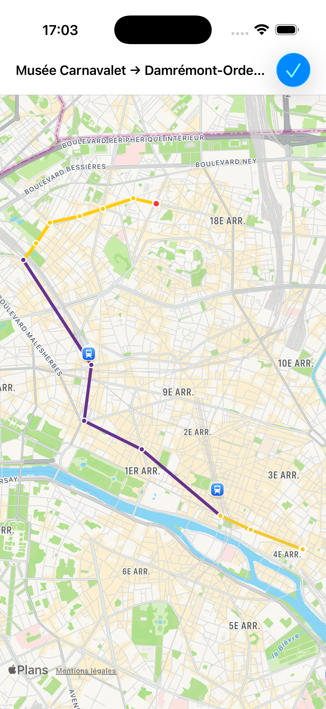
Carnavalet → Damrémont
Haltestelle in einer Linienliste antippen
Aus der Haltestellenliste einer Linie (durch Antippen eines Linienabschnitts in den Ergebnissen) platziert das Antippen einer Haltestelle diese direkt in das aktive Eingabefeld (![]() Abfahrt oder
Abfahrt oder ![]() Ankunft).
Ankunft).
Eingabefeld
Haltestellenfarben in einer Linienliste
Bei der Anzeige der Haltestellenliste einer Linie (aus den Ergebnissen oder dem Linien-Tab) werden Haltestellen nach ihrer Rolle farblich gekennzeichnet:
| Farbe | Bedeutung |
|---|---|
| Rot | Haltestelle, die genau Ihrer eingegebenen Abfahrt oder Ankunft entspricht |
| Blau | Haltestelle des geöffneten Detailblatts oder geografisch nahe an Ihrer Abfahrt / Ankunft |
| Grau | Geschlossene Haltestelle (in den Stadtdaten als außer Betrieb markiert) |
| Schwarz | Normale Haltestelle |
Langes Drücken (Finger > 1 Sekunde halten)
| Wo | Ergebnis |
|---|---|
| Zusammenfassungs-Banner (Titel- oder Statistikzeile) |
🔊 Sprachausgabe der vollständigen Route (Text-to-Speech) in der Oberflächensprache |
| Fußweg-Schritt | Öffnet Fußgänger-Navigation |
| Haltestelle in einer Linienliste | Öffnet das Detailblatt der Haltestelle |
| Haltestelle im |
Öffnet das Detailblatt der Haltestelle |
| Ort im |
Öffnet das Detailblatt des Orts |
| Kontakt in der Kontaktliste | Öffnet die Kontaktkarte im Adressbuch |
Weitere Gesten
| Geste | Ergebnis |
|---|---|
| Öffnet das iOS-Teilen-Menü — Kopieren, E-Mail, SMS, AirDrop… mit dem vollständigen Routentext | |
| Gerät schütteln | Berechnet sofort mit den aktuellen Feldern neu (entspricht der Los-Schaltfläche) |
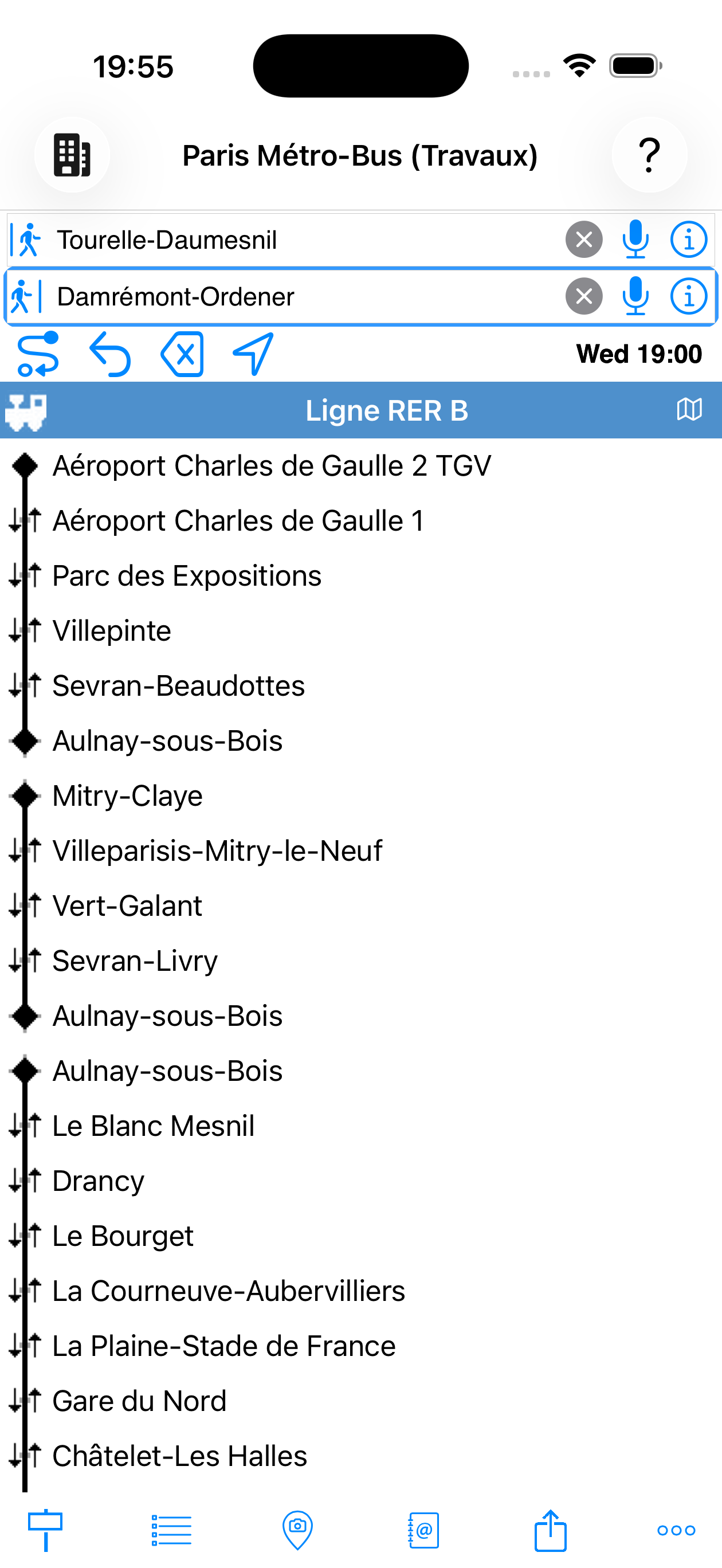
Der ![]() Linien-Tab (untere Leiste) listet alle Verkehrsgruppen der aktiven Stadt auf. Die Navigation erfolgt auf zwei Ebenen:
Linien-Tab (untere Leiste) listet alle Verkehrsgruppen der aktiven Stadt auf. Die Navigation erfolgt auf zwei Ebenen:
- Eine Gruppe antippen (U-Bahn, S-Bahn, Bus…), um alle Linien zu sehen
- Eine Linie antippen, um alle Haltestellen in Reihenfolge mit Umstiegen anzuzeigen
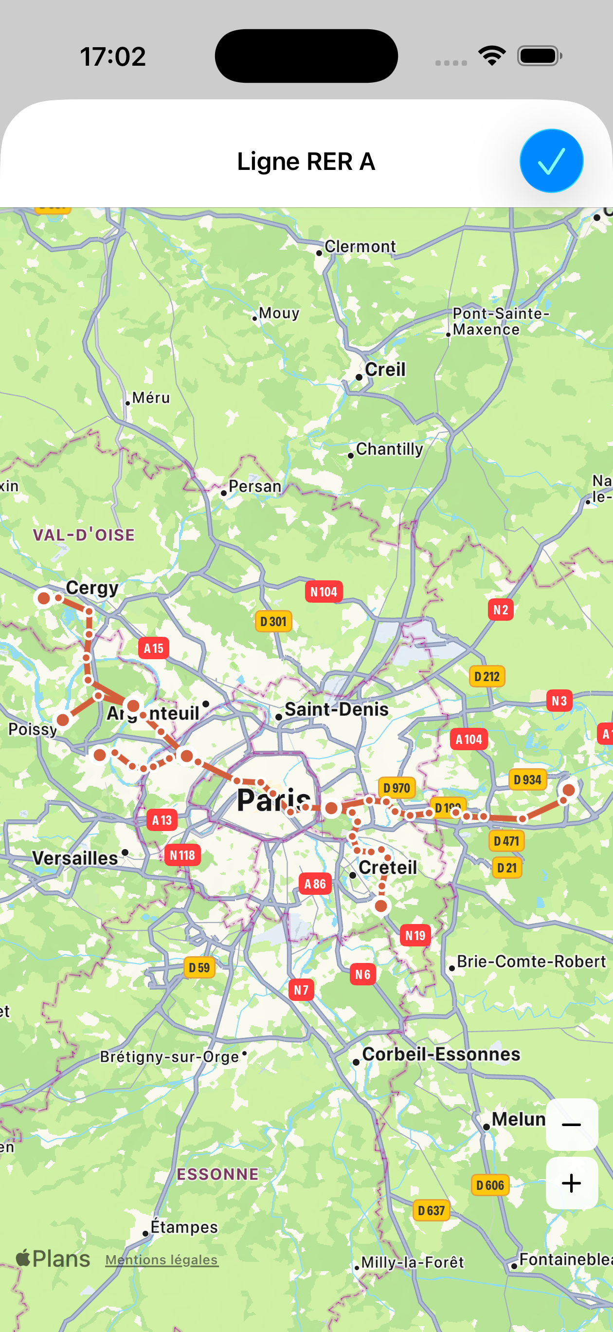
Eine Karten-Schaltfläche oben in der Haltestellenliste zeigt den geografischen Verlauf der Linie.
mit Umstiegen ↕
Tippen Sie auf die Karten-Schaltfläche in der Haltestellenliste einer Linie, um ihren vollständigen Streckenverlauf anzuzeigen.
Verkehrsmittel filtern
Deaktivieren Sie ein Element, um es von der Berechnung auszuschließen.
Anwendungsbeispiele:
- Linien im Wartungsbetrieb ausschließen
- Bestimmte Verkehrsmittel aus Gründen der eingeschränkten Mobilität vermeiden
- Eine Route erzwingen, die nur die U-Bahn nutzt
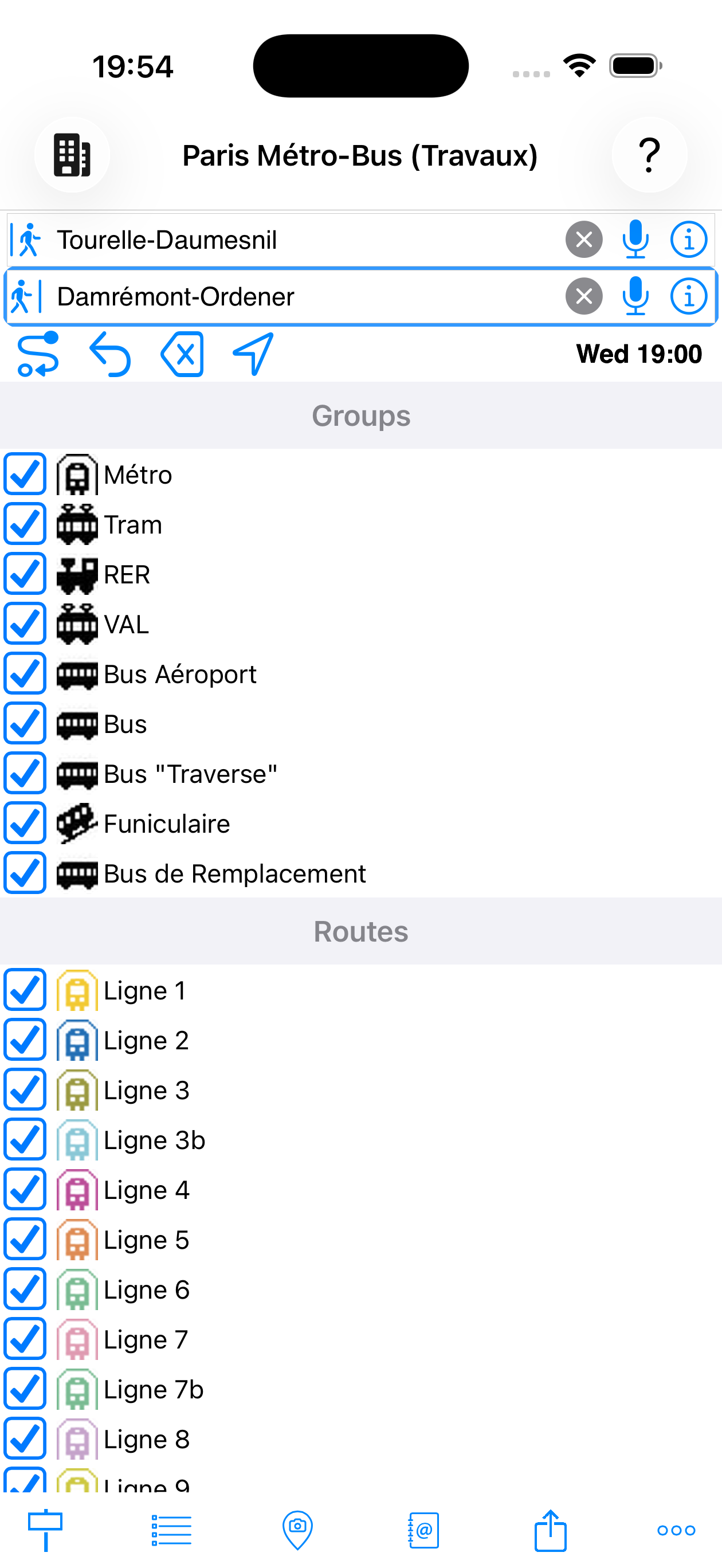
und Linien aktiv
Tippen Sie auf eine Gruppe, um sie aufzuklappen und Linien einzeln zu aktivieren/deaktivieren. Die Berechnung startet automatisch neu mit den neuen Filtern, wenn Sie zum Hauptbildschirm zurückkehren.
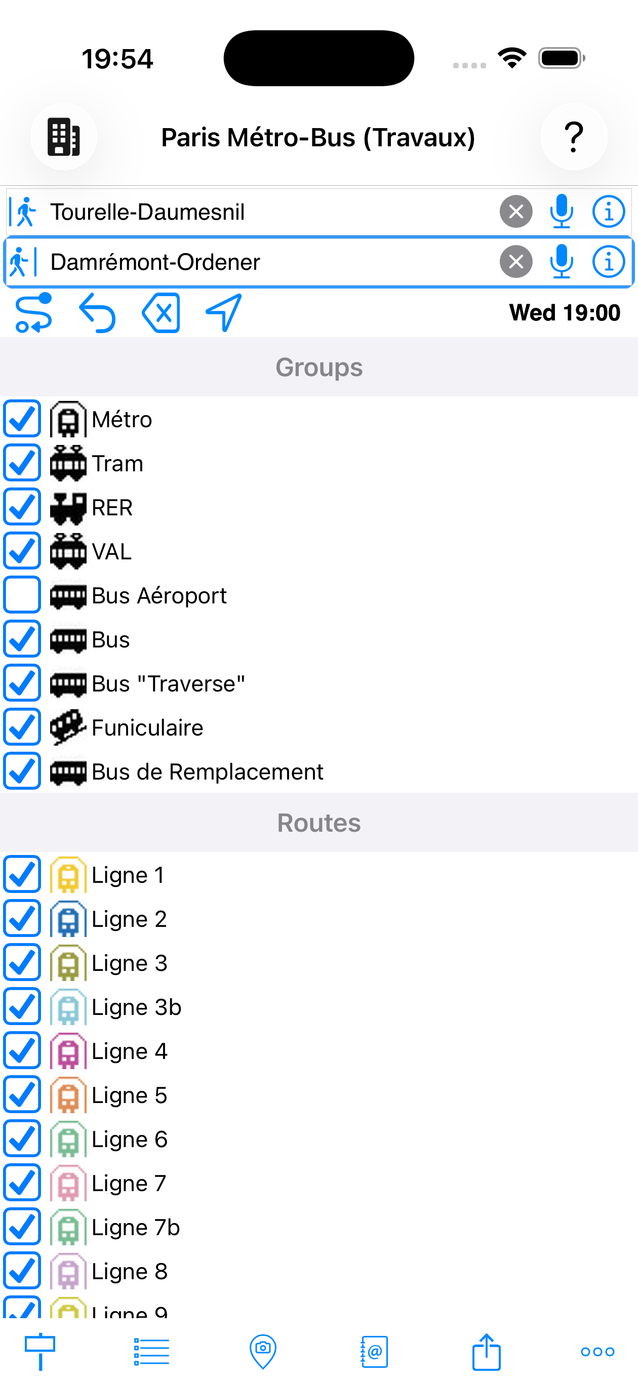
deaktiviert
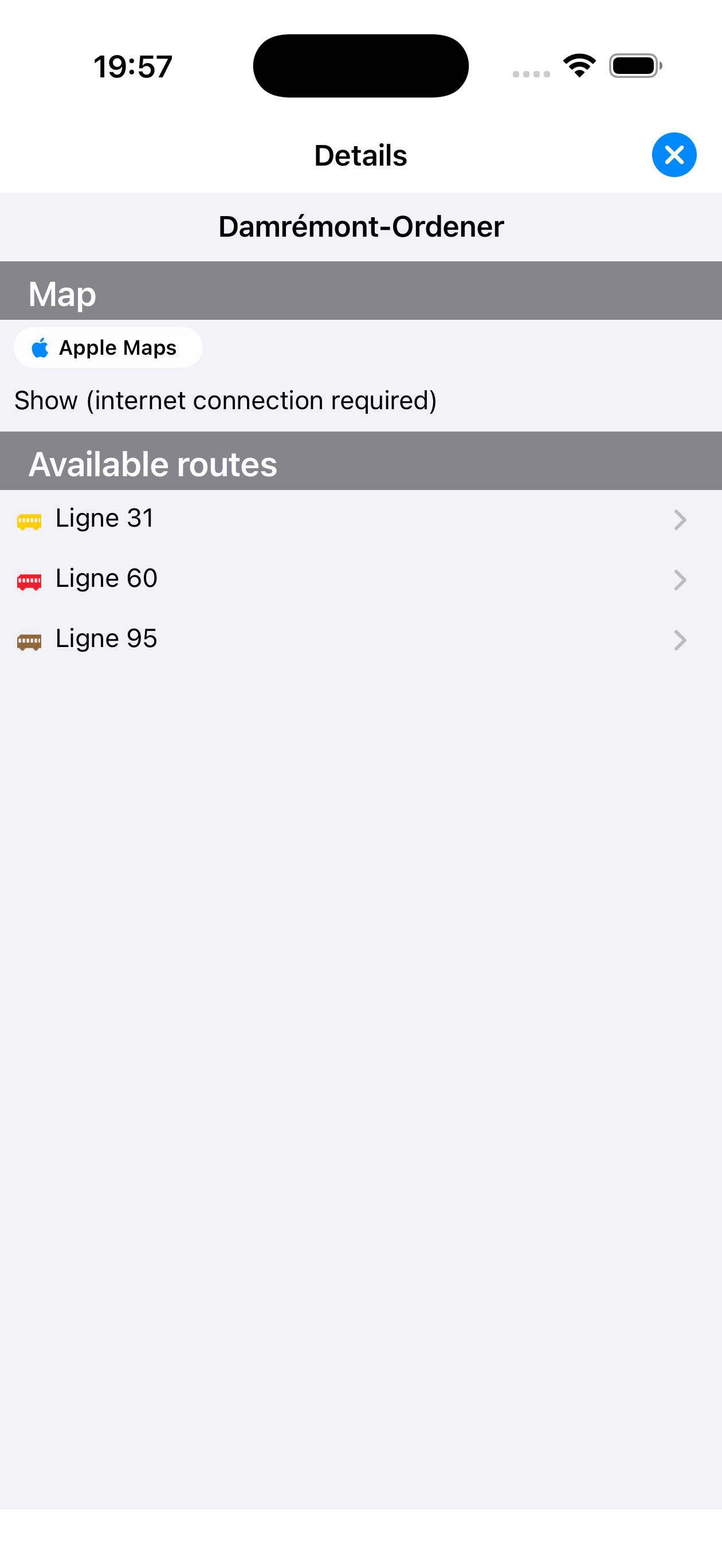
Haltestellendetail-Blatt
Zugänglich über die ⓘ-Schaltfläche neben einem Eingabefeld oder durch langes Drücken auf eine Haltestelle. Enthält:
- Karte — Standort auf einem Plan
- Nahegelegene Haltestellen — Stationen in der Umgebung
- Verfügbare Linien — mit offiziellem Symbol und Farbe
Tippen Sie im Blatt auf eine Linie, um die vollständige Haltestellenliste zu öffnen.
Kartensymbole im Haltestellenblatt
| Marker | Bedeutung |
|---|---|
| Betrachtete Haltestelle oder POI — der Ort, dessen Blatt Sie lesen | |
| Nahegelegene Haltestelle — antippen, um ihr Blatt zu sehen | |
| Verkehrs-POI in Verbindung mit dem Blatt |
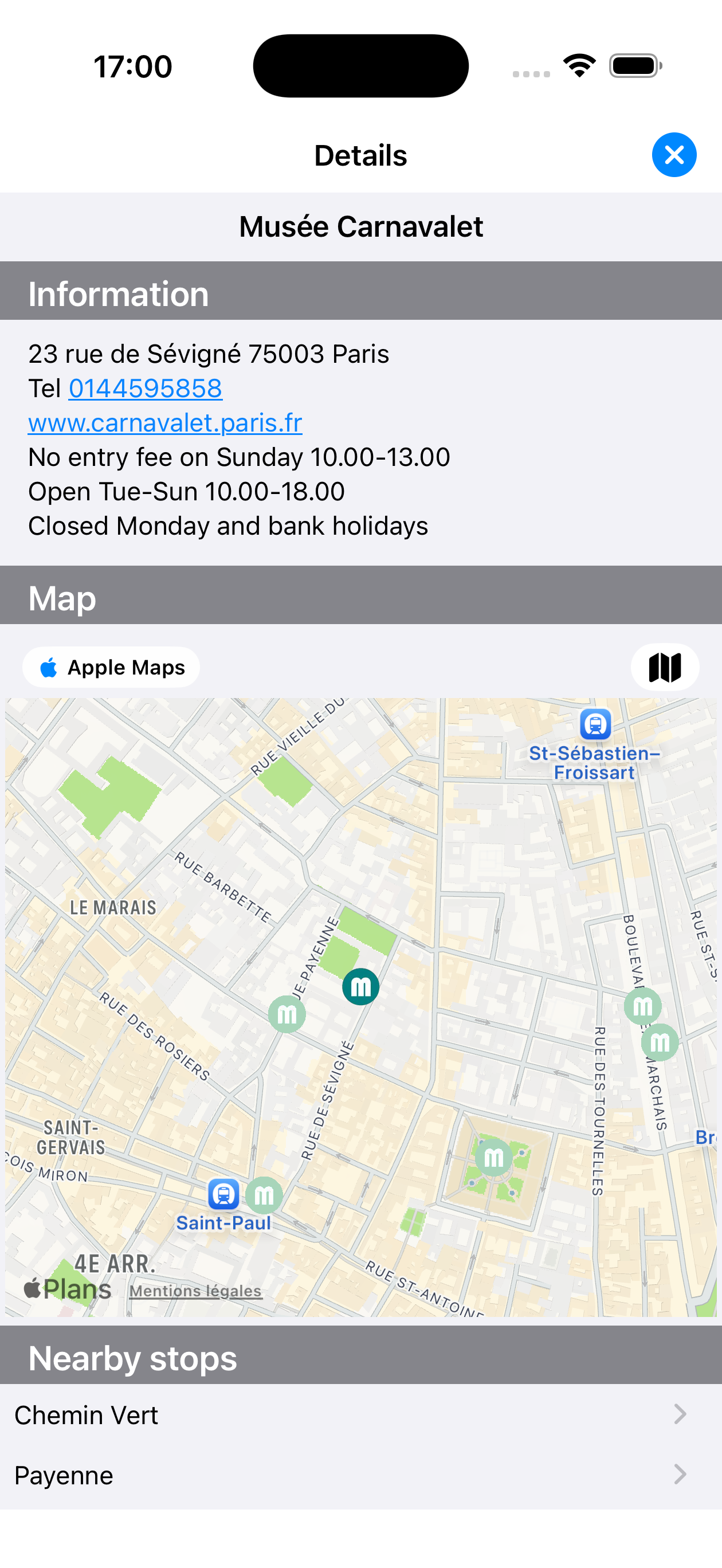
Musée Carnavalet
Sehenswürdigkeits-Blatt
POI-Blätter (Museen, Bahnhöfe, Flughäfen, Hotels…) zeigen auch praktische Informationen: Adresse, Telefon, Website, Öffnungszeiten, Anfahrt. Nahegelegene Haltestellen und verfügbare Linien ermöglichen es, den Ort direkt von Ihrer Route aus zu erreichen.
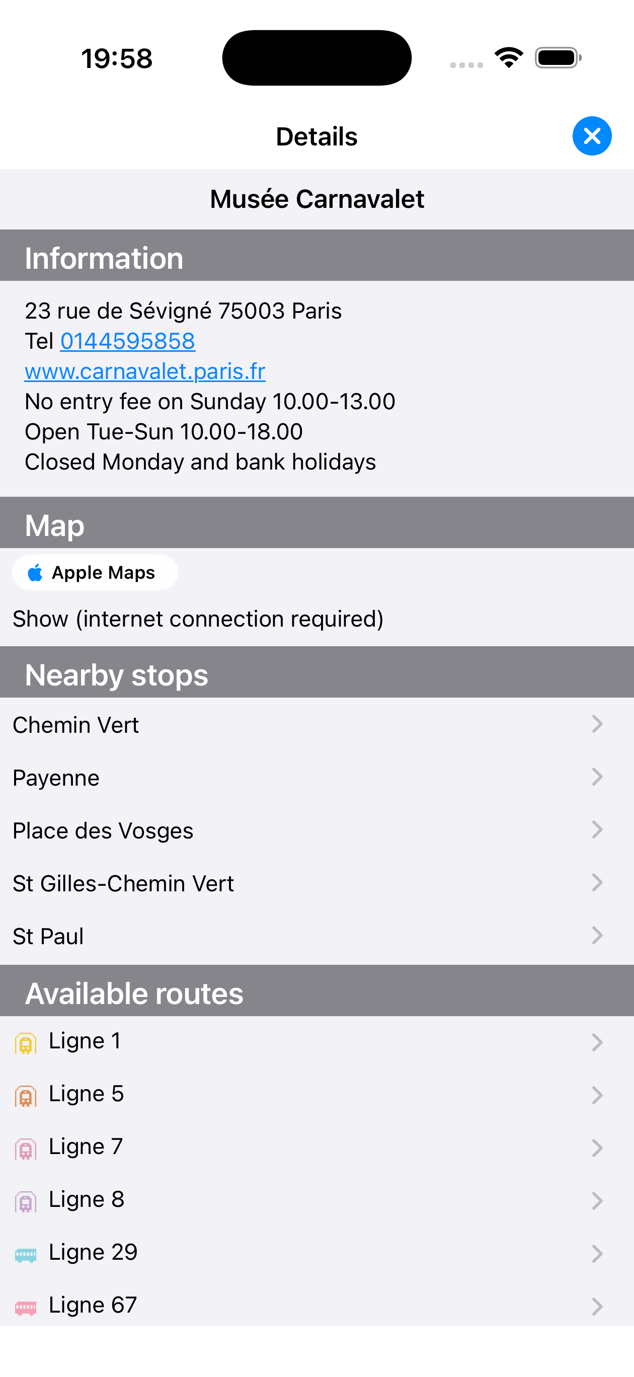
Musée Carnavalet
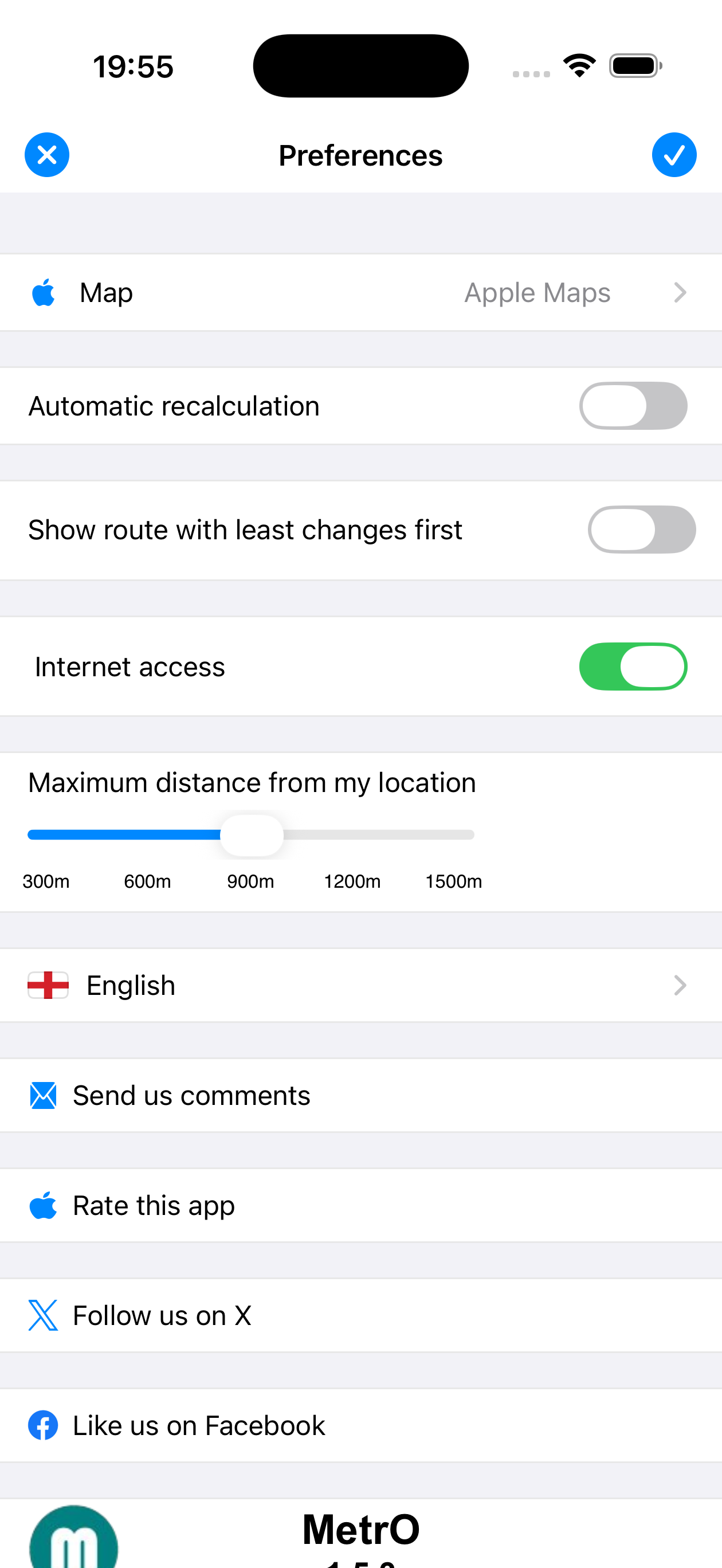
Der ![]() Einstellungen-Tab (Tab-Leiste unten rechts) enthält alle App-Einstellungen:
Einstellungen-Tab (Tab-Leiste unten rechts) enthält alle App-Einstellungen:
| Einstellung | Beschreibung |
|---|---|
| Karte | Apple Maps, Google Maps, Bing, OpenStreetMap, MapLibre, OpenRouteService |
| Automatische Neuberechnung | Wenn Abfahrt auf Mein Standort gesetzt ist, wird die Route automatisch neu berechnet, sobald Sie sich mehr als 100 Meter seit der letzten Berechnung bewegt haben |
| Wenigste Umstiege zuerst | Priorisiert Komfort gegenüber Geschwindigkeit |
| Internetzugang | Wenn deaktiviert, arbeitet MetrO vollständig offline: Stadt-Downloads und -Updates werden blockiert, Karten in Detailblättern deaktiviert, Wetter nicht verfügbar. Nützlich zur Kontrolle des Mobilfunk-Datenverbrauchs |
| Max. Entfernung (GPS) | Suchradius für nahegelegene Haltestellen (300 m bis 1.500 m) |
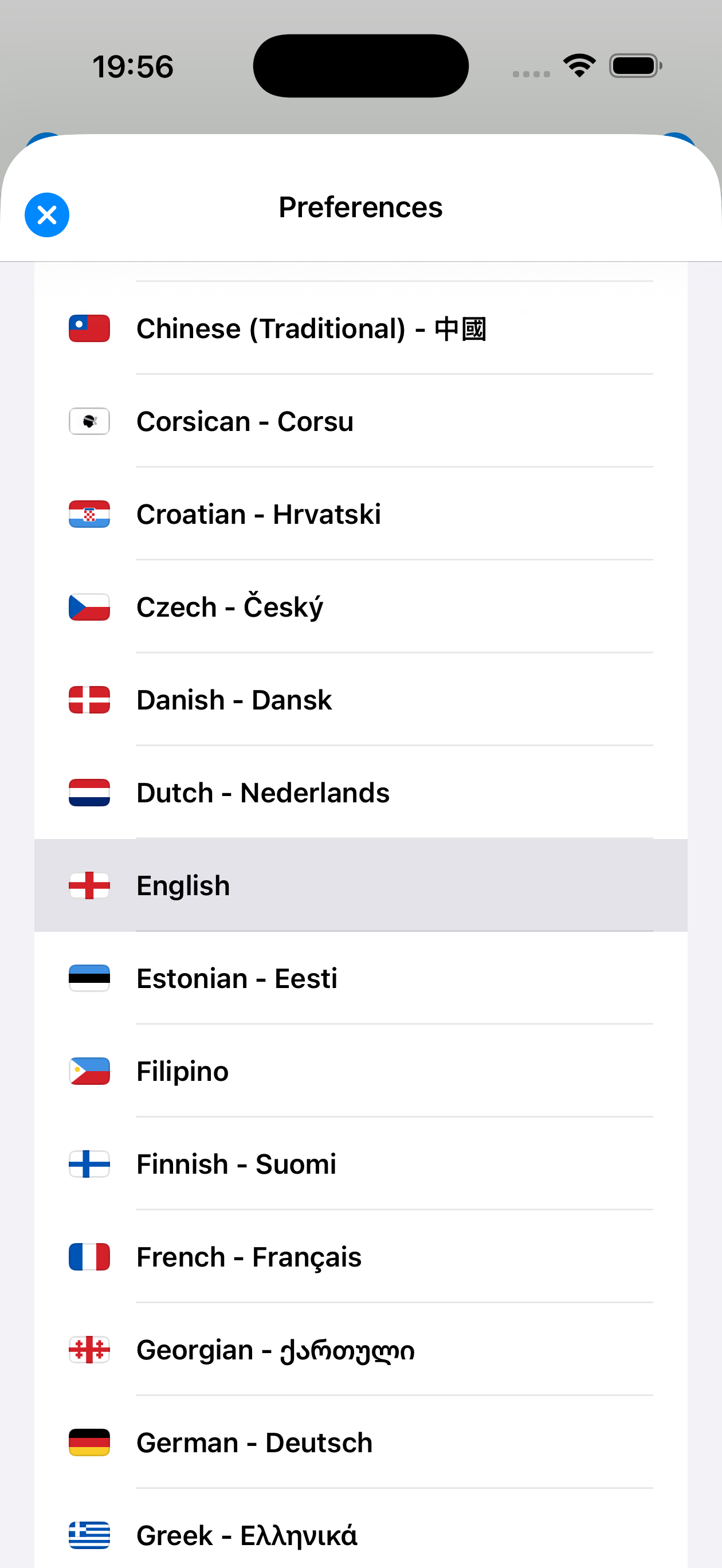
| Sprache | Oberfläche in +50 Sprachen verfügbar (einschließlich Arabisch, Hebräisch, RTL) |
| Kommentare senden | Fehler oder Netzwerkänderungen an die Autoren melden |
| App bewerten | Öffnet MetrOs App Store-Seite für eine Bewertung |
| Twitter / X | MetrO-Neuigkeiten auf X (ehemals Twitter) folgen |
| MetrOs Facebook-Seite |
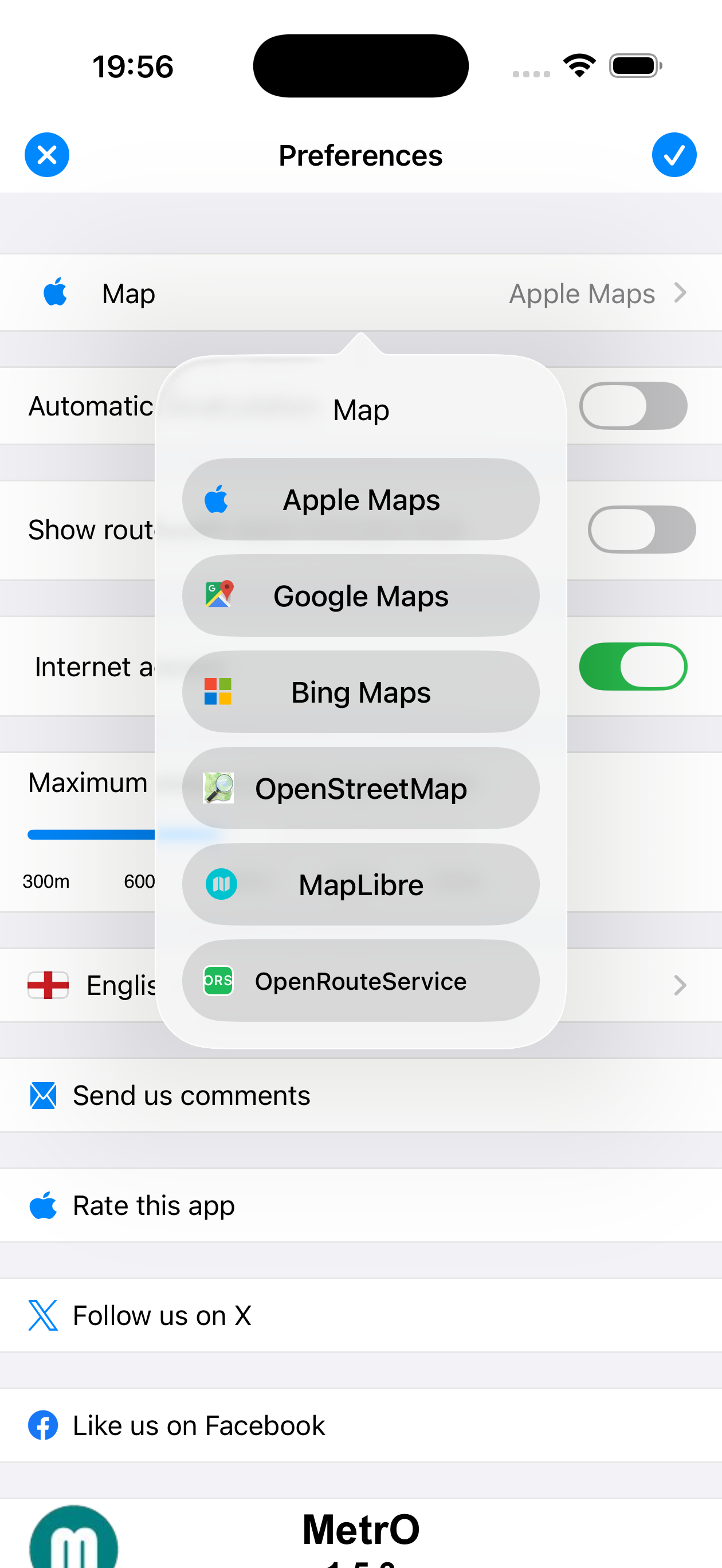
6 Kartenanbieter verfügbar
Mehrsprachige Oberfläche, RTL-Unterstützung
MetrO passt sich automatisch an das Querformat an: Die Eingabefelder werden nebeneinander angeordnet und die Tab-Leiste verschiebt sich an den Rand, um den verfügbaren Platz für Ergebnisse zu maximieren.
Rechts-nach-links-Schriften (Arabisch, Hebräisch…) werden nativ unterstützt: Die gesamte Oberfläche spiegelt sich, wenn Sie die entsprechende Sprache in Einstellungen → Sprache wählen. Beide Modi können kombiniert werden.
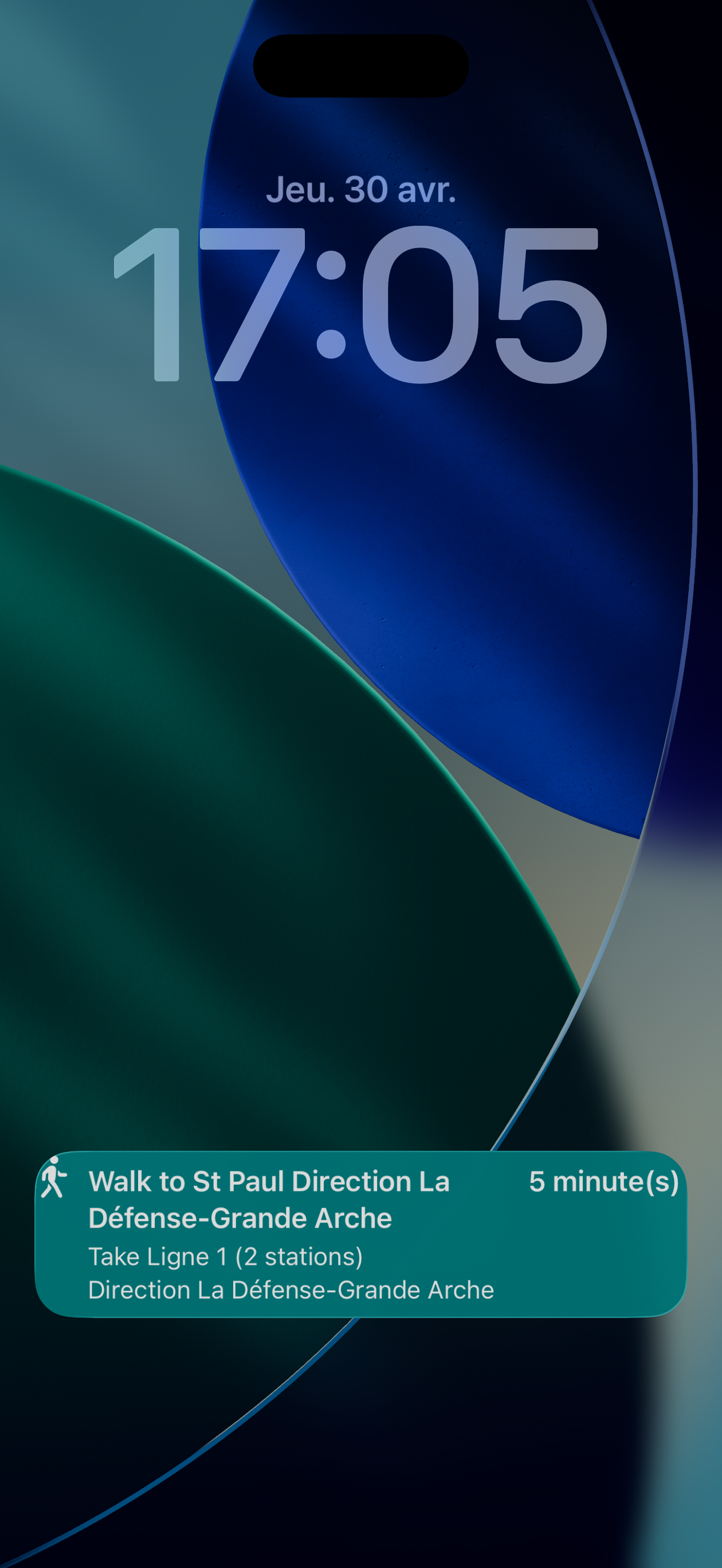
Sperrbildschirm-Benachrichtigung
MetrO kann während der Navigation eine dauerhafte Benachrichtigung auf dem Sperrbildschirm anzeigen. Sie zeigt:
- Den nächsten auszuführenden Schritt (gehen oder einsteigen)
- Die geschätzte Restzeit
- Richtung und Anzahl der Haltestellen
Tippen Sie auf die Benachrichtigung, um direkt zur aktuellen Route zurückzukehren.
auf dem Sperrbildschirm
Spotlight-Suche
MetrO ist in die iOS Spotlight-Suche integriert. Wischen Sie vom Startbildschirm nach unten und geben Sie den Namen einer Haltestelle oder eines Orts ein: MetrO schlägt direkt passende Ergebnisse vor. Tippen Sie auf ein Ergebnis, um die App mit der vorausgefüllten Haltestelle zu öffnen.
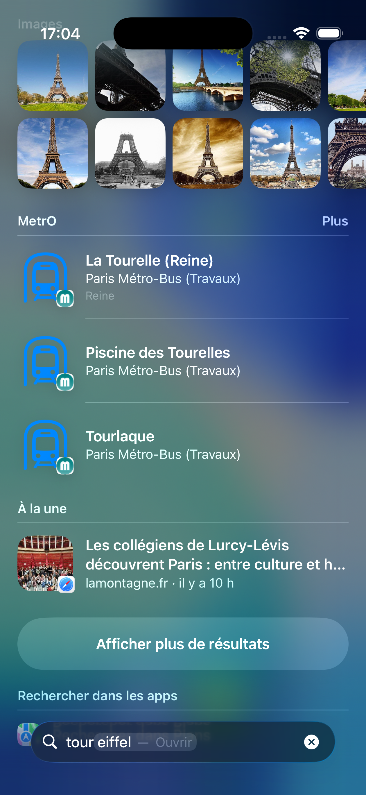
„tour eiffel"
Symbol-Kurzbefehle
Ein langes Drücken auf das MetrO-Symbol zeigt Schnellzugriffe:
- Go home (Nach Hause) — trägt Ihre Heimatadresse (aus Ihrer Kontaktkarte) direkt in das Ankunftsfeld ein
- Go to work (Zur Arbeit) — trägt Ihre Arbeitsadresse in das Ankunftsfeld ein
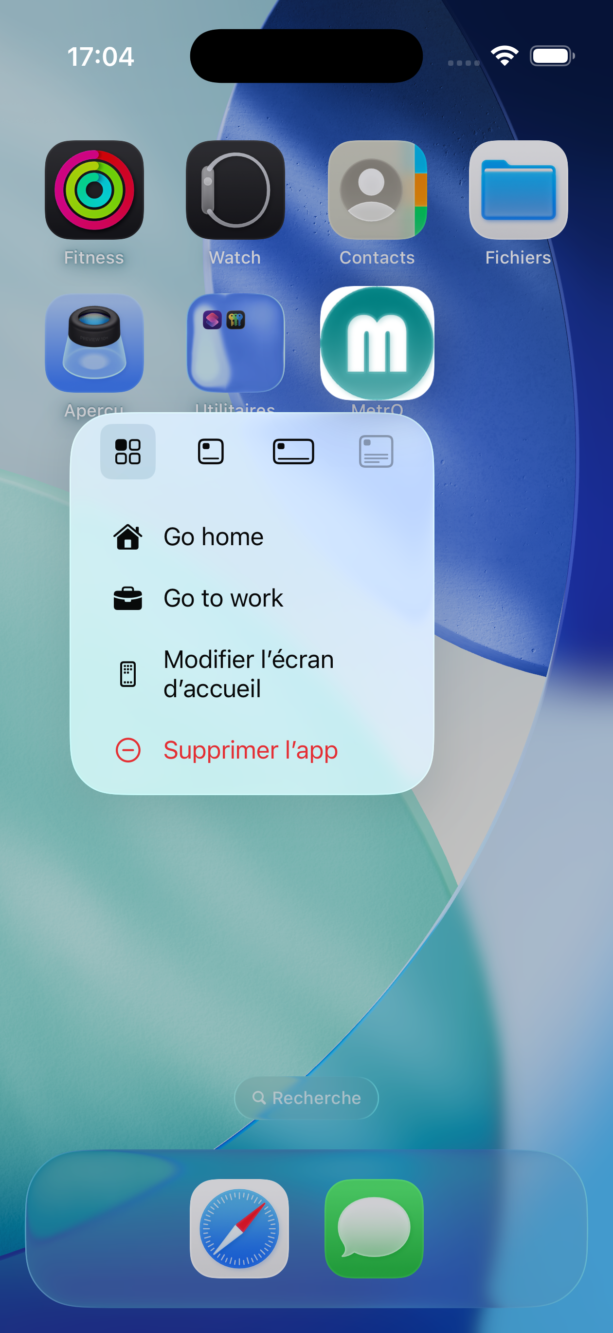
langes Drücken auf Symbol
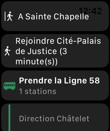
MetrO enthält eine Apple Watch-Begleit-App, die Ihre aktuelle Route direkt am Handgelenk anzeigt.
Sobald eine Route auf dem iPhone berechnet wurde, wird sie automatisch an die Watch übertragen:
- Zu nehmende Linien — mit farbigem Symbol und Haltestellenanzahl
- Umstiege und Ausstiegshaltestellen
- Fußweg-Umstiege mit geschätzter Dauer
- Linienrichtung als Untertitel angezeigt
Wenn die Watch noch keine Daten erhalten hat, fordert sie diese automatisch vom iPhone an, sobald die Bluetooth-Verbindung verfügbar ist. Öffnen Sie MetrO auf Ihrer Watch: Die Route erscheint innerhalb von Sekunden.
Komplikation — MetrO kann die aktuelle Routenzusammenfassung direkt auf Ihrem Watchface anzeigen.
Apple Watch
- Wählen Sie Ihre Stadt durch Antippen ihres Namens oben am Bildschirm, bevor Sie eine Route eingeben.
- Geben Sie nur wenige Buchstaben ein — die Autovervollständigung erledigt den Rest.
- Nutzen Sie das Verlaufsfeld, um einen aktuellen Trip schnell ohne erneute Eingabe zu starten.
- Bei Streiks oder Bauarbeiten deaktivieren Sie die betroffenen Linien (
 Filter), um eine alternative Route zu erhalten.
 - Tippen Sie auf den blauen Banner eines Ergebnisses, um die Route auf der Karte anzuzeigen.
- Schütteln Sie das Gerät, um mit den aktuellen Abfahrts-/ Ankunftsfeldern neu zu berechnen.
- Nutzen Sie Teilen, um die Route per SMS, E-Mail oder AirDrop an Ihren Reisebegleiter zu senden.
| Copyright © 1997–2026 Kinevia SARL. Alle Rechte vorbehalten. Letzte Aktualisierung am 01.05.2026 |
MetrO… |